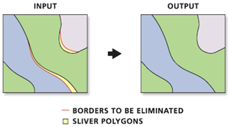
One common problem in GIS is combining layers from different sources such as the boundary between two piece of property or even two countries. These are tyipcally combined together with "Merge" and then you can find "slivers" or areas of overlap between the polygons and "gaps" or areas where there spaces between the features.

These sliver polygons can cause problems both with analysis and with creating maps. You can prevent these from occuring by setting an "X,Y tolerance" on your overlay operations.
Also, see managing topology in future GIS classes.
© Copyright 2018 HSU - All rights reserved.